

Summit Date
August 4, 2002, around 12:00 noon
Party
Ryan Cragun, Tom Triplett, Mark Woolley
Trip Report
As I experience more highpoints, I am realizing (though it may seem quite obvious) that the summits that require more exertion also receive much longer trip reports. So is the case with Boundary Peak.
I climbed this peak with Tom Triplett and Mark Woolley as part of our 1 per year goal to climb one peak per year together to help maintain our relationship as we leave home and explore the world. Since our last hike, King’s Peak, both Tom and Mark have married and Tom has a son, Tate. We had originally thought to climb Gannet Peak in Wyoming, but as we learned more about it, we realized that we are just not ready for a hike of that intensity. Instead, we decided to climb Boundary Peak in Nevada. As it turned out, I was going to be coming to Utah to drive my wife home from her 6-week internship at the beginning of August, so we planned the hike for the time that I would be in Utah. We originally thought about climbing Mount Whitney during the same trip, but because of time constraints and the realization that invariably, after hikes like these, we are exhausted and sore for a couple of days, we thought better of that as well. We would just do Boundary Peak.
We left the Salt Lake area around 10:00 am on Saturday, August 3 in Mark’s Nissan Sentra. About 2 hours later, we stopped in Wendover for lunch at the Peppermill casino (inexpensive buffets are groovy). A couple hours later we passed through Ely and then continued on to Tonopah. The conversation was lively because of some of the changes that have taken place in our lives, and that made the time pass quickly. Tonopah, NV was the last relatively large town that we passed through before leaving major roads and entering the dirt roads that would take us to the trailhead.
It was on the entrance road that we first encountered events that would change the entire trip. About 5 miles into the entrance road, some rocks bouncing up underneath the car knocked a connection to the muffler on Mark’s car loose. Though Mark claimed that he knew he was going to have to get a new muffler soon anyway, the timing was inopportune. We still had another 10 miles to the trailhead and had a pipe that is supposed to be connected to the muffler hanging down about 6 inches lower than it should have been. And, the road was just getting narrower and rougher. The last four miles of the entrance road were pretty rough. At several points Tom and I got out of the car to help guide Mark and to raise the clearance. Miraculously, we made it to the trailhead, but at the expense of Mark’s muffler, his paint job, and possibly even his clutch.
When we arrived at the trailhead, there wasn’t anyone there. It was about 6:00 pm. Interestingly, there was a green minivan about 300 feet below the trailhead with a scantily clad couple in it. Perhaps we were jealous because we had all left our wives in Utah, but we couldn’t help but wonder what the couple might be doing.
Anyway, Mark was concerned about his car, reasonably so, because by the time we made it to the trailhead, the pipe that was hanging down was even lower. We needed some wire or something that wouldn’t melt or burn to tie it up so we could at least make it back out and possibly home without dragging Mark’s exhaust pipes. We had innumerable nylon straps and ropes, but we didn’t have anything along the lines of metal wire. Not 30 minutes after we arrived at the trailhead, a family of highpointers (The McBride’s – Dan, Kate, Ian, Molly, & Erin) came down the trail. They had climbed Boundary Peak in about 11 hours round trip time and were tired. Even though we had some decent directions and ok maps, we wanted to get first hand experiential wisdom from someone that had just climbed the summit. We engaged them in conversation and they were more than willing to engage us back. We ended up talking at the trailhead for a good 20 minutes. They are from Rochester, NY. As a family, they have completed 42 highpoints, except the youngest, who is three behind at 39. They have been highpointing for 7 years. They had rented a van for their highpointing trip and because of the difficulty of the entrance road, they ended up camping about a mile from the trailhead so as not to damage their vehicle. We would have gladly driven them to their camp, but Tom and I had walked nearly the last 1/2 mile to the trailhead so as not to drag the exhaust pipe on the road. We told them so and then asked if they might have wire or a hangar so we could tie it up. They said they did and we offered to take their packs down to their camp and walk with them if we could get the hangar so we could tie up the pipe. Only the older daughter handed over her pack, but we did walk to their camp with them and enjoyed the conversation. They are quite experienced highpointers and are highpointer club members. I talked with the mother the entire time and Mark and Tom walked with the others. They even gave us cookies at their camp (as if we had done something to deserve it, they were the ones helping us), we exchanged contact info and said goodbye. If the McBride’s ever read this, thank you for your information about the hike, your conversation, your hospitality, and your hanger, you’ll never know how much it helped.
When we got back to the trailhead, Tom and I set up the camp and gathered some firewood while Mark tied up the exhaust pipe on his car. When everything was done, we sat around the campfire for a while and chatted before going to bed around 11:00 pm. We thought it might get pretty hot during the day so we planned to leave while it was still dark, around 5:00 am.
We left our camp while it was still dark, though the sky was getting lighter and headed out. There are some cows that linger near the trailhead and we ran into them. With a little noise, the cows left and left us alone. We hiked through the foliage for about an hour before leaving the denser foliage and finding ourselves at the base of the scree mountains that must inevitably be climbed to summit. We knew there were several routes up the mountain, but decided not to make the decision as to which route to take until we were actually faced with the decision and knew what we were really facing. We stopped for a few minutes at the base of the wash and the top of the foliage and contemplated the climb. As we understood it, we had two options that were commonly used. We could continue kind of west or to the right and work our way up to the saddle. Or we could turn to the south or left and climb the face. As we thought about it, we realized that climbing the face would be an experiment in futility and frustration. The face is pure scree and we would be taking one step backward for every two steps forward. Also, it wasn’t too steep at the base, but once you got close to the northeast ridge (which blocks the view of the actual summit and looks like it might be the summit), the slope is incredibly steep. Though it is likely the most direct route, it is by no means the easiest. If we were to stay to the right and work our way up the saddle then follow the ridge up to the summit, it might be easier, but it is going to be longer than the more direct route.
We didn’t like the options, so we opted for our own. Between the right and left routes is a ridge that leads to a peak that, from the east of Boundary Peak, looks to be just to the right of Boundary Peak and a bit lower in elevation. Nearly 2/3 of the ridge is covered with foliage and large rocks, meaning we wouldn’t be hiking through scree. The slope is pretty steep, but we would be making progress, not sliding down as we try to climb up. Just where the foliage ends is a knoll that we thought would give us a reasonably clear perspective of whether or not we should continue all the way up the ridge or from the knoll cut across, skirting the lower summit and working our way to the ridge that leads up to the northeast ridge and eventually to the summit. This route wouldn’t be quite as long as the saddle route to the right or north, but it would be a bit more difficult. At the same time, it wouldn’t be as short as the direct ascent of the face, but it wouldn’t be even remotely as difficult as a direct ascent on the face.
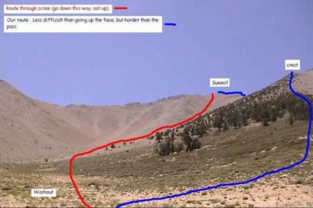
We thought our idea was a good one, so we headed up the ridge. About an hour later, we made it to the knoll. This was probably 2 1/2 hours to 3 hours into our hike. From the knoll we could see a low point in the ridge, leading up to the northeast ridge. If we climbed across the scree and angled up, it would be difficult, but we wouldn’t have to climb the lower summit and would actually make the ridge at the point that would mean we would have to do the least amount of climbing. The cut across from the knoll to the ridge took about another hour and the effects of the elevation were really wearing on us, but it was probably the hardest part of our climb the entire time.
While we were cutting across the scree, we first heard and then saw 2 of the 3 other people we would meet on the trail to Boundary Peak. We ran into them again later, but at this point, we were astonished to see them trying to climb the route up the face. One of them was making incredible time and actually seemed like he was going to beat us up to the northeast ridge. He was like a madman climbing that hill. Further up the ridge, we were within calling distance of each other and he finally could see us. He was realizing at this point that he was on a bad route and was getting very tired. He asked us if it would be easier to cut across from where he was and hike up the ridge like we were doing. We told him that it wasn’t scree where we were and that it should be much easier going. He and his companion eventually crossed over and climbed the ridge. The trail that he was following leads from the washout all the way up to just left or south of the northeast ridge which hides the summit. We realized later what that trail was really there, for going down, not up. (I’ll talk more about it later, but this is a very important point.)
Once we made it to the ridge, we could see the trail that comes up from the saddle to the north. The route also bypasses the summit that we had bypassed, but we had cut across on the east side instead of the west side. From there, we followed the ridge and trail that is often marked by little piles of rocks up to the northeast ridge and from there to the summit. From where we joined the ridge trail to the summit took us another couple of hours. Our total summit time was about 6 hours.
We spent nearly an hour on the summit. We shared some fruit, took a bunch of pictures, and even laid down for a few minutes and took a brief nap. The view was great. There is a box with a bunch of letters and a make shift register on top. The USGS marker is also cemented into the summit. Someone took the initiative to carry some pornographic pictures to the top. Why this gives them a thrill, I don’t know that anyone will ever know, but my belief is that highpoints should be as pristine as possible; whoever you are, the pictures are gone now.
The going on the way back down was much easier. Just below the northeast ridge, we ran into the two hikers we had seen climbing the face. They looked exhausted and were furious that they had tried to climb the face of the mountain instead of taking an easier route. Their information on the routes didn’t tell them where to hike and they decided to follow the only visible trail. They were also highpointers and also from New York, but they were from Long Island. We chatted for a while and explained that they should come down the way that they were trying to come up. A word to the wise, don’t try to climb up the summit route, only use it going down.
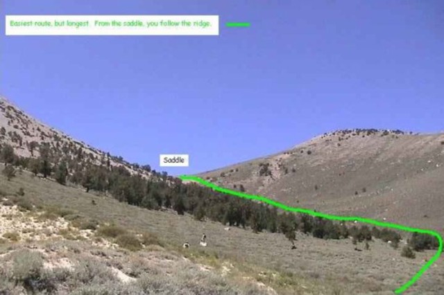
In talking to the McBride’s, they had recommended that we climb the saddle and follow the ridge, then, coming down, they recommended that we follow the ridge to the north until we reach the lowest saddle between the summit to the north of Boundary Peak and the northeast ridge and then drop down into the scree that eventually links up with the trail we had seen the hikers take up the face. They said that dropping down through this scree cut their descent from the ridge to the washout down to 30 minutes. We had considered dropping right down the trail that climbs the face, but this looked incredibly steep and we knew that the McBride’s had successfully dropped through the scree to the north of there, so we decided to follow their path. It was wonderful. Hopping down through the scree made every step into three or four steps and made our descent from the ridge to the washout only 20-25 minutes. On the way down we ran into another man that was trying to climb the face approach. We tried to warn him, but he dismissed our recommendations.
We continued down the scree to the washout and then crossed back to the foliage and caught the trail again. We made it back to our camp at about 2:00 pm. Making our total hike time about 9 hours. Not knowing exactly how long the hike would take us for sure, we had planned on staying that night and driving home the next day, but we were done by 2:00 and realized we could be home by midnight. Throwing everything into the car, we headed out.
It wasn’t until we were off the dirt roads and headed back toward civilization that we realized how sunburned we were. Two of us were carrying sunscreen up the mountain, but because our hike was so cool, we didn’t think much about using it. We put a little of it on just below the summit, but it was just on our noses, which made it out for the most part unscathed. However, we didn’t realize that we were frying, so we didn’t worry about. Anyway, we made it home, the car was loud, but functioned fine and we had successfully completed another highpoint.
Let me end with this advice. Whatever you do, do not attempt to climb the face of the peak that leads to the northeast ridge. That is where you come down, not go up. Going up, you are much better off hiking up the saddle to the far north and then catching the trail that bypasses the lower summit and follows the ridge up. Or, you can follow our route up the ridge and then cutting across the scree and catching the ridge trail. Either way, this is going to be a tough hike, but don’t make it worse than it has to be. Come down one of the scree trails, don’t go up it.
Panorama

Directions
Here’s a map from Tonopah, NV:

![]()
