

Summit Date
August 8, 2002, around 8:00 am
Party
Ryan Cragun and Debi Cragun
Trip Report
“This was the most beautiful highpoint I have seen.” -Debi Cragun.
This was Debi’s first highpoint. We left Utah on August 7th at around 6:00 am. We had originally hoped to leave earlier so we could do Black Elk Peak (formerly Harney’s Peak) on the 7th, but ran into some problems on the way. As we were headed into Casper Wyoming, the brakes on our Ford Escort (my wife’s car from before we were married – I have to justify owning a Ford) were squealing. Knowing we still had about 2200 miles left to travel, we thought it might be a good idea to stop and at least have the brakes looked at. Two hundred dollars and 3 1/2 hours later, we had new front brakes and rotors and no more squealing when we braked. This pushed us even further back than we had planned.
As we headed out from Casper toward the South Dakota state line, it started to rain. What’s a little rain? Well, not much when it is just a little rain. But this wasn’t really just a little rain. Twenty minutes into the rainfall, the lightning that had been striking all around us decided it was time to give us a good scare. Striking no more than 100 feet away from the road to our left side, our car was lit up like a searchlight had just hit us and the powerful boom nearly knocked me right off the road. This should have been enough to encourage us to stop, but we continued on. The rain became harder and denser until we eventually had to stop for about 5 minutes to let the worst of it pass so we could at least see as we drove. We eventually forced our way through the storm, all the while noticing an inordinate number of bikers on the side of the road either putting on or taking off rain gear.
Once we made it through the first storm, we noticed another storm to our south and one to our north. We thought we might drive between them, and we did, though we skirted the north side of the southern storm that also had lightning striking all around us and then drove north just in front of the northern storm and watched it pass behind us. At this point, we knew we weren’t going to hike Black Elk Peak that night, so it was just a matter of finding a place to stay and getting something to eat. Hot Springs, South Dakota was advertising a large number of hotels and places to eat, so we drove there and did find a nice Mexican Place, but all of the hotels were completely full. We brought camping equipment but were a little afraid of the storms that were brewing and were hesitant to set up our meager tent knowing the fortitude of the storms that were advancing. Nothing was available in Hot Springs and by this time we were becoming quite aware of the fact that there were more bikers in South Dakota than there are mosquitoes. They were everywhere. As we found out later, there was a biker rally going on in Sturgis, about 70 miles to the north, and somewhere between 500,000 and 700,000 bikers were slowly converging on that spot. They had taken every hotel/motel room and campground for miles.
When we couldn’t find a hotel in Hot Springs, we headed north to Custer. Same story. Realizing we weren’t going to find a free hotel room, we decided to try our luck camping near the trailhead for Black Elk Peak at the Sylvan Lake Campground. We drove up that way, but it was nearly 11:00 pm by that time and all of the campsites were taken. Not wanting to backtrack, we pulled into the Sylvan Lake store’s parking lot and slept in the car until about 5:00 am. Perhaps that should be restated; Debi slept until 5:00 am and I rolled around in the car, uncomfortable and semi-conscious for most of the night. Not wanting to feel the guilt that would come with not paying the park entrance fee, we backtracked to the Ranger’s station and paid the $12.00 fee for one car and drove into the trailhead parking for Black Elk Peak.
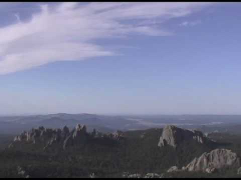
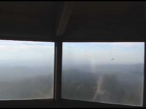
We started hiking around 6:30 and made it to the summit at 8:00. The hike was beautiful. Debi is a rock buff and was amazed at the amount of mica mixed in with the gravel of the trail. We stopped a couple of times at some scenic look out points and snapped pictures and one other time to put on sunscreen (since I was still feeling the consequences of not putting it on when I climbed Boundary Peak). The trail is well-marked and the summit is a constructed trail of rocks cemented into stairs and an old fire watch tower. The tower was built in 1939 and is multi-storied. We spent about half an hour on the summit, snapping pictures and enjoying the view. The view from the summit is superb. The hike was not too difficult, with only a few points where you have to maneuver over or through rocks. We had not seen anyone else on the trail.
We headed down around 8:30 and saw the first people we had seen on the trail just below the summit. The going down was easier than coming up, but hiking up wasn’t even that difficult. When we were about half way down the trail, we ran into several other groups, perhaps twenty people in all. It was nice to have the summit to ourselves. By 9:15 we were back to the trailhead.
We stopped at Mt. Rushmore, a definite must see if you haven’t been there, before heading on to White Butte, North Dakota.
Final thoughts: This was one of the three most beautiful highpoints I have done, the others being Clingman’s Dome in Tennessee and King’s Peak in Utah.
Panorama
Here’s another view from inside the tower on the highpoint:
![]()
