

For my work, a colleague and I decided to propose a new travel study course that would involve a combination of our interests – sociology of sport (hiking, specifically) and exercise science. Our original course proposal wasn’t approved, but our International Programs Office agreed to fund us to scout out a trek in Peru to improve our application and fill in details for the second time we propose the course. As a result, a colleague (Abe) and I spent a week in Peru in August of 2018. We spent a few days in Cuzco acclimating before heading out on the (Super) Salkantay Trek which covers about 34 miles (64 kilometers) in 3 days, ending in Aguas Calientes. The following day we took a bus to Macchu Picchu. This post is a brief summary of the trek.
We flew from Tampa to Miami on a Saturday afternoon and then from Miami to Lima that evening, arriving around 9:30. In retrospect, we should have spent the night in Lima and then caught a flight to Cuzco the next day after getting a good night’s sleep. Instead, we spent about 5 hours in the Lima airport (me trying to sleep; Abe pacing the airport) until our 3:50 am flight to Cuzco. The travel agency that arranged our trip included an airport transfer to our hotel which, unfortunately, wasn’t ready when we arrived at around 5:30 am. So, we kind of slept on couches in their lobby until our room was ready around 8:30. By that time, daylight was upon us so we went out exploring in Cuzco. We spent a couple of days in Cuzco exploring the city and the cuisine while acclimating to the elevation (Cuzco is at just over 11,000 feet). We visited some museums, tried a few restaurants, and even did a trial hike up to the Temple of the Moon, Q’Engo Chico, el Cristo Blanco, and Saqsaywaman.
Here’s the route we took:

Despite having spent a day in Cuzco, we could still feel the elevation as we hiked and knew it would take a little while to acclimate to this elevation.
In the afternoon on our second day in Cuzco, we met up with the rest of our group for the (Super) Salkantay Hike at the headquarters of G Adventures and met our guide, Ever. There were 16 of us total: 3 from the US, 1 from Canada, 2 from Switzerland, 2 from Denmark, 2 from South Africa, 2 from Wales, and 4 from England. We had a briefing session, had a chance to rent any gear we needed, and then were given duffels that would carry our sleeping bags and pads and any extra gear as we would only have to carry day packs during the day. Porters (using donkeys) would carry the duffels, tents, and food from campsite to campsite. Having just completed a serious climb of Mt. Rainier in Washington, this seemed like a walk in the park – let someone else carry all the heavy stuff and I just have to get myself from point A to point B every day. Elevation aside, I wasn’t expecting a particularly challenging hike.
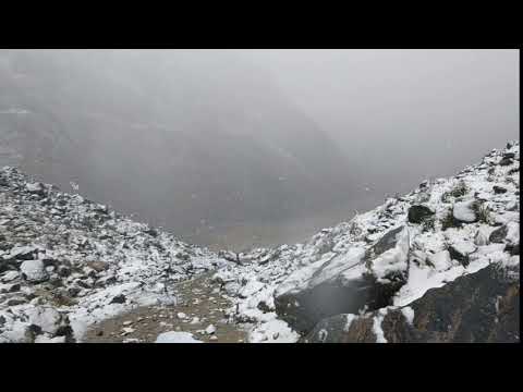
On August 6th, we got up around 5:00 am, had a quick bite to eat at our hotel, then hopped aboard a bus that drove us out to the beginning of our hike (stopping for a more substantial breakfast on the way). We started hiking around 10:30. It quickly became apparent that we had different levels of hikers in our group, with several quickly falling behind. I tried to stay at the front as I didn’t want to get caught behind a slow hiker. Our guide, Ever, set a pretty good pace. About 30 minutes in, we started to have light rain and everyone donned their rain gear (for many, this was just light ponchos; luckily, I have complete rain gear for hiking – top and bottom). As we continued, we started to gain some elevation. The rain also started to get a little harder. As we got higher up in elevation, the rain started to transition into sleet. Eventually, it became snow. Basically, we were caught in a snowstorm on our way to Salkantay Pass, which is over 15,000 feet in elevation.

We continued our ascent and the snow got thicker. We stopped about an hour from the pass for lunch. The porters had set up a tent on about 6 inches of snow for us to dine in and had already prepared hot water so we could have tea and hot chocolate. They also made us a hot meal (soup and chicken tenders with rice). It was still freezing cold in the tent but we were largely out of the wind. I was generally warm with all my layers on (except for my hands in my light gloves), but there were many in our group who were much less prepared (one guy was in shorts the whole time). Additionally, one member of our group was slow enough that they had her ride a horse part of the way up the mountain.
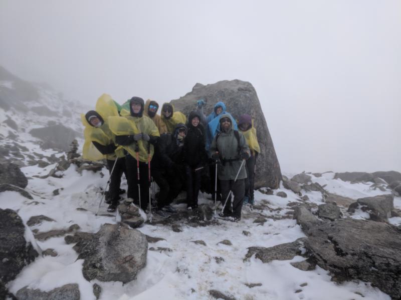
After lunch, we continued up the mountain, eventually making it to the pass where most of us huddled behind a large rock to get out of the wind as best we could while we waited for the rest of our group to make it to the top. Our huddle reminded us of a bunch of penguins trying to avoid the cold.
We stayed on the summit until everyone had made it to the highest point of our hike then began our descent down the other side. It didn’t take long before the wind died down. Then we descended below the snow line and were hiking in mud and light rain. We hiked until just after 6:00 pm when the first wave of us made it to the camp for the night just as it got dark enough to warrant headlamps. It was very cold and raining at the camp but the camp had some buildings with tin roofs (where we ate and the porters slept) and our tents were already set up. The stragglers took another 30 to 45 minutes to arrive in the dark with flashlights.
Here’s the route from the first day of the hike:
Per my watch, we covered 8.84 miles. Our starting elevation was about 12,562 feet; our peak elevation was 15,175 feet (highest I’ve ever hiked). The total elevation gained during the hike was 3,006 feet.
We had about 45 minutes to get our sleeping bags and pads set up before dinner. At dinner, we once again had warm drinks (which were a delight) and ate well. The guide also laid out the plan for the next day, which was the longest hiking day.
We went to bed around 9:00 but the hot drinks worked a number on our bladders. Abe got up to pee four times. I had to get up once, around 10:00 pm, to pee. Given the urgency, I didn’t put my pants back on and was caught in someone else’s headlamp in my underwear taking a piss. When you got to pee, you got to pee!
We were up again around 5:00. We packed up and were met with warm water to make tea and hot chocolate or coffee again. After our meal, we finished gearing up and getting ready for our longest day of hiking. Here’s a photosphere of the campsite:

Since we arrived when it was nearly dark, we really couldn’t see the amazing mountains that surrounded our campsite. In the morning, we had a few breaks in the clouds and realized just how amazing the location was. Alas, we only saw it for about 30 minutes before we headed down.
We had a lot of hiking ahead of us – all day. However, it was also all down hill. As we descended, we crossed from a high altitude mountain region into a wooded area and eventually into the rainforest. It was actually quite interesting as our guide said that we would know when we were in the jungle when we saw bamboo and palm trees, both of which I have in my backyard in Tampa, Florida – I guess I live in the jungle.
I tracked our hike from morning until we stopped for lunch (when I had to recharge my watch). Here’s the route:
We did 6.58 miles before lunch, descending about 4,000 feet.
We stopped for lunch for a bit over an hour. I made the poor decision to take my socks off to air out my feet to try to prevent blisters only to get bit about a dozen times by black flies in the 5 minutes I had my socks off. Terrible idea. My feet itched nonstop for the next three days!
Anyway, after a yummy lunch, we hit the trail again (though, at this point, three members of our group opted to take a van down to our campsite for the night). We hiked through a beautiful area surrounded by mountains and began passing plantation after plantation – corn, avocado, passion fruit, and squash were the major crops. We even stopped at one to break into a passion fruit:

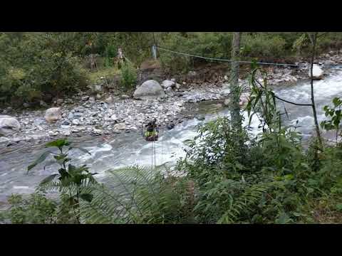
We were hiking next to the Santa Teresa River for most of the afternoon. There was a road on one side of the river but people lived on the other side. In order to cross it, they built cable bridges and would pull themselves across, like the man in this video did:
Towards the end of the day, I was getting tired. It wasn’t hard hiking like the day before but we just kept going and going. We finally reached our campsite just as it was getting dark around 6:00 pm after hiking another 10.53 miles. Here’s the route:
Our campsite this night was basically at the far end of a town, La Playa Sahuayaco, and even had a small bar near our campsite (where we could get beer and pisco sours, which we, of course, got). There was also a hot shower here. We had another 45 minutes to set up our sleeping bags in the pre-arranged tents before dinner. After dinner, our guide explained that our porters would be headed back over the mountain the next day to prepare for the next group of hikers and from here on our gear would be transported by vehicle. He also explained what our hike would be like the next day – a steep climb up a mountain until we overlooked Macchu Picchu followed by a steep descent then a bit of a march to the train station where we’d catch a train to Aguas Calientes and spend the night in a hotel.
Our third day of trekking was as described. We had a relatively steep ascent up a mountain but it was definitely worth it. On the way, we stopped at one break area that had a pretty cool rope swing that allowed you to swing out over the mountain:

It was a short distance after this that we made it to Mirador Llactapata, which is an Incan ruin as well as a lookout spot over Macchu Picchu.
We stayed here for a bit then began our descent down the mountain. It was close to two hours of a steep descent. At the bottom, we crossed another rope bridge then walked for a bit to a train station where we had a late lunch then boarded our train to Aguas Calientes. After three days, we got to take a shower and sleep in comfortable beds. It was nice getting back to civilization. Total mileage for the day: 8.59 miles.
Our total mileage from the hike: 34.54 miles spread over three days.
![]()
